Harun Nasrullah
The UN General Assembly has overwhelmingly backed a resolution calling for greater use of world maps that accurately represent Africa’s size, with the US standing alone in opposition.
The “Correct the Map” resolution, sponsored by Togo and supported by African Union member states, was adopted on September 4 with 164 countries voting in favour, while the US was the only country to vote against it and six abstained.
The non-binding resolution is expected to encourage UN bodies and other institutions to reconsider the maps they use.
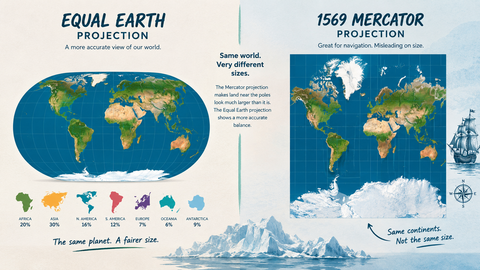
The campaign centres on the world map commonly known as the Mercator projection, created by Flemish cartographer Gerardus Mercator in 1569. Widely used for navigation because it preserves direction, it makes land masses near the poles appear much larger than they are.
Africa, covering about 30.4 million square kilometres, is roughly 14 times larger than Greenland, yet the Mercator projection makes the two appear comparable in size.
African campaigners and scholars have long argued that repeatedly presenting Africa as smaller than it can influence perceptions of the continent’s political, economic and cultural importance.
The African Union’s 54 member states adopted the Equal Earth projection in February, describing it as a more accurate representation of the relative size of the world’s continents, particularly Africa.
Togo’s Foreign Minister Robert Dussey, who led the campaign at the UN, said, “A fair world begins with a fair map.”
French Foreign Minister Jean-Noël Barrot backed the initiative and said France would stop using the Mercator projection.
“Changing the map obviously doesn’t change the world. But correcting a representation that distorts it is already an act of truth,” Barrot said.
The US opposed the resolution.
Yaryna Ferencevych, representing the US at the UN, criticised the General Assembly for devoting attention to the issue.
“Instead of focusing on genuine problems of international peace, prosperity, or good relations, this body is debating map projects from the 16th Century, and their role in promoting reparations and ‘cognitive justice’,” she said.
Campaigners welcomed the vote.
Lerato Mogoatlhe of Africa No Filter said Africa’s distorted representation was “not just a cartographic error – it’s a narrative issue”.
Kenyan geographer Kioko Muendo said maps influence how regions are perceived politically and economically, including perceptions of Africa’s resources, population and investment potential.
The Equal Earth projection, developed in 2018, seeks to preserve the relative area of continents more accurately than the Mercator projection.
The vote does not legally require governments, schools or organisations to abandon Mercator maps. However, campaigners say the UN endorsement could accelerate the adoption of more proportionally accurate alternatives.
The resolution comes amid wider efforts by African countries and institutions to challenge representations of the continent they regard as rooted in colonial-era thinking.
The campaign does not make Africa larger. Instead, it seeks to ensure that maps show its actual scale relative to the rest of the world.